Share
ShareWhat are the Different GNSS Correction Methods?
-
 July 10, 2026
 -

 13 min read
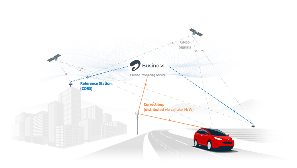
GNSS corrections are essential for achieving high-precision positioning. Uncorrected GNSS (Global Navigation Satellite System) signals typically provide an accuracy of 5–10 metres, which is insufficient for demanding applications like precision agriculture, autonomous navigation, fleet management, and surveying. By applying error corrections to these signals, accuracy can be improved by up to 100x, reaching centimetre-level precision.
This blog will walk you through the primary GNSS correction methods—Differential GNSS (DGNSS), Satellite-Based Augmentation Systems (SBAS), Real-Time Kinematic (RTK), Precise Point Positioning (PPP), and PPP-RTK—exploring what each method offers, where it works best, and where its limitations lie. We also look at how cutting-edge GNSS correction services, such as Airtel Precise Positioning, are making high-accuracy location technology more accessible to enterprises across India and highlight the role of cutting-edge GNSS correction services like Airtel Precise Positioning.



But first, how does standard GNSS positioning work?
At its core, GNSS works by measuring how long it takes for signals from multiple satellites to reach a receiver on the ground. Each satellite continuously broadcasts a signal that carries information about its identity, position in orbit, and the exact time the signal was sent. A GNSS receiver picks up these signals from several satellites simultaneously and uses the travel time of each signal to calculate how far away each satellite is. With enough distance measurements, the receiver can pinpoint its own location in three dimensions.
In practice, however, a number of factors introduce errors into this process. Signals are slowed and bent as they pass through the Earth’s atmosphere. Satellite clocks and orbits are not perfectly precise. And in dense urban environments, signals can bounce off buildings and other structures before reaching the receiver, further distorting the measurement. The combined effect of these factors results in a typical positioning error of 5–10 metres for uncorrected GNSS: accurate enough for everyday navigation, but far too imprecise for industrial and enterprise applications. GNSS correction methods exist to close this gap.
Differential GNSS (DGNSS)
DGNSS improves positioning accuracy by comparing a receiver’s GNSS measurements against those from a fixed reference station installed at a precisely known location. Because both the reference station and the user’s device are receiving signals from the same satellites at the same time, they experience many of the same errors. The reference station calculates what those errors are and broadcasts correction data in real time. The user’s device applies these corrections to its own measurements, cancelling out the shared inaccuracies and improving positional accuracy to under a meter.
The key advantage of DGNSS is its simplicity: it requires minimal processing power, works with standard GNSS hardware, and achieves fast positioning. The trade-off is coverage: the corrections are only effective within a limited range of the reference station, and the accuracy degrades the farther a device moves away from it.
Pros: Simple to implement, widely available, sufficient for non-critical applications, low processing power required at the receiver, fast convergence time, ideal for receivers with a constrained antenna such as mobile devices.
Cons: Lower accuracy than RTK or PPP, limited range from the base station.
Use Cases: Marine navigation, some agricultural operations, and recreational positioning.
Asset Tracking with Differential GNSS Corrections
For enterprises managing large fleets, equipment, or cargo, DGNSS offers a cost-effective way to track assets in real time. Sub-meter accuracy is sufficient to monitor vehicles across logistics networks, machinery on construction sites, and containers moving through supply chains. Because DGNSS hardware is compact and energy-efficient, it can be embedded into small, battery-powered trackers without significant infrastructure investment. For use cases where centimetre precision is not a requirement, DGNSS delivers reliable performance at a practical cost.
Satellite-Based Augmentation System (SBAS)
SBAS operates on a similar principle to DGNSS, using a network of ground-based reference stations to detect errors in satellite signals, but with a key difference in how corrections are delivered. Rather than broadcasting from a local reference station, corrections are computed centrally and transmitted to users via geostationary satellites. This allows SBAS to cover entire continents without requiring users to connect to any local infrastructure.
The trade-off is precision. Since the corrections are designed to work across a very large area, they are less tailored to any specific location than DGNSS corrections. This makes SBAS a reliable choice for applications that need consistent, broad coverage rather than pinpoint accuracy.
India has its own SBAS implementation: GAGAN (GPS Aided GEO Augmented Navigation), jointly developed by the Indian Space Research Organisation (ISRO) and the Airports Authority of India (AAI). GAGAN provides satellite-based corrections across the Indian subcontinent and surrounding airspace and is certified for use in civil aviation, making it a foundational component of air navigation safety across the country.
Pros: Free-to-use (in most regions), no additional infrastructure needed for users, wide-area coverage.
Cons: Limited accuracy compared to RTK or PPP, dependent on regional SBAS infrastructure.
Use Cases: Aviation, maritime navigation, and agriculture applications that do not require centimetre-level precision.
SBAS in Aviation
In aviation, SBAS provides far more than accuracy; it also delivers integrity, meaning it actively alerts pilots and systems when the positioning data cannot be trusted. This is a non-negotiable safety requirement for instrument-guided approaches and landings. GAGAN plays this role across Indian airspace, enabling aircraft to navigate and land safely even in low-visibility conditions. For airlines and airport operators, SBAS represents a proven, infrastructure-light solution for precision air navigation at scale.
Real-Time Kinematic (RTK)
RTK delivers centimetre-level positioning accuracy in real time, making it one of the most precise correction methods available for operational applications. It works by pairing a GNSS receiver in the field with one or more fixed reference stations. Both the receiver and the reference station track the same satellites simultaneously, and the reference station continuously transmits correction data to the receiver. This allows the receiver to resolve its position to within 1–2 centimetres almost instantaneously.
What makes RTK so accurate is that it also analyses the signal’s carrier wave, which oscillates at a far higher frequency and therefore allows for much finer measurement. Resolving these highly precise measurements requires sophisticated processing, but once complete, the system locks onto a highly accurate position fix that is maintained in real time.
However, the practical constraint of RTK is its range. Corrections are most effective within approximately 20–30 kilometres of a reference station. Beyond that distance, accuracy degrades. This makes RTK ideal for controlled environments or regions with good reference station coverage but less suited to applications that require seamless positioning across large or open geographies.
Pros: Fast convergence, high accuracy (2 cm).
Cons: Limited coverage area (usually within 20–30 km of a base station), requires reliable network connectivity (if using NTRIP).
Use Cases: Autonomous vehicles, outdoor robotics, precision construction or land surveying in controlled areas.
RTK Corrections in Robotics
In robotics, the margin for error is often measured in centimetres. Agricultural robots rely on RTK to navigate rows of crops with the precision needed to plant, treat, and harvest without waste or damage. Inspection drones use RTK to hold accurate flight paths in complex environments. On construction sites, RTK-guided machinery can position components and execute tasks with a level of consistency that manual methods cannot reliably achieve. For any enterprise deploying autonomous or semi-autonomous systems in the field, RTK-grade positioning is typically the baseline requirement.
Precise Point Positioning (PPP)
PPP takes a different approach to high-accuracy positioning. Rather than relying on nearby reference stations, it draws on a global network of monitoring stations that track satellites continuously and generate highly accurate data on each satellite’s exact position and clock behaviour. This data is distributed to users worldwide, allowing any PPP-capable receiver to correct its measurements independently, without needing to connect to local infrastructure.
The result is genuinely global coverage at centimetre-level accuracy, which is a significant advantage for operations in remote or offshore locations where reference stations simply do not exist. The trade-off is time. A PPP receiver needs to accumulate enough satellite observations to confidently resolve its position, a process that can take anywhere from 10 to 30 minutes. Once converged, however, it maintains high accuracy indefinitely. This makes PPP well suited to applications where positioning is established before an operation begins, rather than being needed instantly on the move.
Pros: Global coverage, high accuracy (centimetre-level), no need for local base stations.
Cons: Long convergence times (up to 30 minutes), lower real-time capability compared to RTK.
Use Cases: Offshore positioning, global surveying, scientific research, and geodetic applications.
PPP in Maritime Navigation
At sea, the absence of ground-based infrastructure is the norm rather than the exception. PPP fills this gap by delivering centimetre-accurate positioning anywhere in the world using only satellite data. For a vessel navigating a narrow channel, conducting underwater surveys, or positioning equipment during an offshore installation, the precision that PPP provides is critical. Moreover, its global reach means it works equally well in the open ocean as it does close to port. Ships typically have time to allow PPP to converge before entering operationally sensitive zones, making its longer initialisation period a manageable constraint rather than a barrier.
PPP-RTK
PPP-RTK is the most advanced correction method available today, combining the broad geographic reach of PPP with the fast, precise positioning of RTK. For enterprises that need centimetre-level accuracy across a national or continental scale, that is, without the cost and complexity of building a dense network of local base stations, PPP-RTK represents the most practical path forward.
The method works by distributing corrections that model individual sources of GNSS error, such as satellite orbits, clock behaviour, and atmospheric conditions, as separate data streams covering wide geographic areas. A receiver combines the relevant components based on its own location and the satellites it can see, building a highly tailored correction picture without needing to be close to any specific reference point. This architecture also scales efficiently: a single correction service can support many thousands of users simultaneously across a large region.
A further enhancement is PPP-RTK’s ability to resolve positioning ambiguities more quickly by using signals across multiple frequencies. By combining observations from different satellite frequencies, the system can establish a reliable position fix in seconds rather than minutes, dramatically improving the practical usability of the technology for real-time applications.
The net effect is a correction method that delivers near-RTK accuracy with near-PPP coverage. It is well suited to any enterprise use case that requires both high precision and the ability to operate seamlessly across large or geographically distributed environments.
Pros: Shorter convergence times than PPP, high accuracy with broader coverage than RTK with a significantly lower number of base stations required.
Cons: Requires more advanced GNSS receivers, slightly lower accuracy than RTK.
Use Cases: Wide-area autonomous navigation, automotive safety, fleet management.
PPP-RTK in Automotive Safety
For autonomous and connected vehicles, knowing exactly where a vehicle is is a foundational safety requirement. PPP-RTK makes this possible at scale, providing the precise, real-time positioning that advanced driver-assistance systems (ADAS) and self-driving platforms depend on. Crucially, PPP-RTK maintains this accuracy across diverse environments, from congested city centres to open highways and mountain roads, making it the preferred correction method for automotive applications that cannot afford gaps in coverage or precision.
Summary of GNSS Correction Methods
|
GNSS Correction Method |
Accuracy |
Time To First Fix |
Baseline |
Typical Use Cases |
|
Standard GNSS |
5–10 m |
~3–10 seconds |
Worldwide |
Consumer navigation apps, fitness trackers, general positioning |
|
SBAS |
~1–3 m |
~30 seconds |
Continental |
Aviation safety, broad-scale agricultural management |
|
DGNSS |
<1 m |
~5–20 seconds |
Local / Regional / Continental |
Entry-level precision agriculture, basic marine navigation |
|
PPP |
~10 cm (static) |
~10–30 minutes |
Global |
Offshore energy operations, global asset tracking, remote surveying |
|
PPP-RTK |
~3–7 cm |
~10–30 seconds |
Continental |
Nationwide autonomous fleet navigation, UAV inspections, smart agriculture |
|
RTK |
~1–2 cm |
~5 seconds |
Local / Regional |
High-precision agriculture, surveying, robotics, autonomous vehicles |
Choosing the Right GNSS Correction Method
Selecting the appropriate GNSS correction method depends on the specific demands of your application: how accurate the positioning needs to be, how quickly it needs to lock on, how wide an area it needs to cover, and what level of infrastructure investment is practical. The methods covered in this blog represent a spectrum of options, from accessible sub-metre solutions suited to logistics and asset tracking to centimetre-precise technologies that underpin autonomous vehicles, precision agriculture, and smart infrastructure.
For enterprises operating in India, access to high-quality GNSS correction services is becoming increasingly critical as industries invest in automation, connected mobility, and data-driven operations. Airtel Business, in partnership with Swift Navigation, is working to make this infrastructure accessible at scale, bringing high-precision positioning services to sectors such as automotive, logistics, agriculture, and robotics, and supporting the next generation of intelligent, location-aware enterprise applications.
Airtel Business, in partnership with Swift Navigation, is enabling access to high-precision GNSS positioning services in India to support next-generation mobility, automation, and connected infrastructure use cases across industries such as automotive, logistics, agriculture, and robotics.
|
Audience |
Will Understand Fully |
|---|---|
|
GNSS Engineers |
100% |
|
Telecom Product Teams |
70% |
|
Enterprise Buyers |
30–40% (70-80% Target) |
Ex – Standard GNSS positioning works by calculating the travel time of signals transmitted from multiple satellites to a receiver. Using these signals, the receiver estimates its location in three dimensions. However, factors such as atmospheric interference, satellite clock drift, orbital deviations, and signal reflections can introduce positioning errors ranging from 5–10 meters.
Raw, uncorrected GNSS signals from each satellite contain a unique pseudorandom noise (PRN) code which communicates three key pieces of information: the satellite’s ID (who), its position in orbit (where), and the onboard time the signal was transmitted (when). A GNSS receiver then calculates the travel time of a signal from a satellite by comparing its internally generated PRN code with the same code embedded in the satellite’s signal. To achieve synchronization, the receiver shifts its code along the sequence until it aligns with the satellite’s PRN code. The amount of this shift corresponds to the time passed since the signal was transmitted, i.e., its travel time. This is called code-phase positioning. Using this information, the receiver can calculate the distance travelled by the signal, known as a pseudorange. Once the distances to four or more satellites are determined, the receiver can infer its own position in three dimensions.
However, GNSS systems are subject to various errors that degrade positioning accuracy, with atmospheric interference being the most significant. As GNSS signals pass through the ionosphere (outer layer) and troposphere (layer nearest the Earth’s surface), they are slowed down and refracted, introducing inaccuracies. Even the highly precise atomic clocks onboard satellites are prone to slight deviations that impact position calculations, as are the satellites’ orbits, which can deviate marginally from their predicted paths. Lastly, in complex environments, GNSS receivers receive multiple copies of the same signal as it bounces off nearby objects such as buildings and trees, affecting its location calculation. These errors compound to an overall positioning error that ranges between 5 to 10 meters. GNSS correction methods are used to reduce these errors.